m (robot Adding: de) |
Lakenheath72 (talk | contribs) mNo edit summary Tag: sourceedit |
||
| (23 intermediate revisions by 15 users not shown) | |||
| Line 1: | Line 1: | ||
| + | {{at|xx}} |
||
| − | [[Image:Cage-screen-17-North-Pacific.jpg|thumb|20th century map depicting the North Pacific region.]] |
||
| − | [[ |
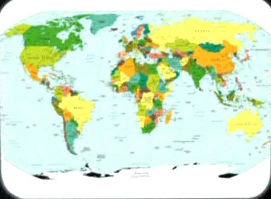
+ | [[File:Earth political map.jpg|thumb|21st century era political map of the Earth]] |
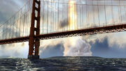
| + | [[File:San Francisco Bay targeted.jpg|thumb|The [[verteron array]] impacts harmlessly in the Pacific Ocean]] |
||
| − | The '''Pacific Ocean''' is the largest ocean on [[Earth]], comprising a third of its surface area. [[Gravett Island]] is located in the Pacific. (''[[Star Trek: First Contact]]'') |
||
| + | :''You may be looking for [[Pacific Ocean Post]].'' |
||
| + | The '''Pacific Ocean''', or the '''Pacific Basin''', was the largest [[ocean]] on [[Earth]], comprising a third of its surface area. Due to its great size, political maps divided the ocean into the North Pacific Ocean and the South Pacific Ocean (aka South Seas), with the [[equator]] being the border between the two regions. Four [[continent]]s - [[North America]], [[South America]], [[Australia]], and [[Asia]] - had coastlines on this ocean. The Pacific Ocean was the location of several islands and island chains, among them [[Gravett Island]] and [[Hawaii]]. Before their [[extinction]] in the [[21st century]], [[humpback whale]]s lived in this ocean. ({{TOS-R|The Cage}}; {{film|4}}; {{film|8}}; {{VOY|The 37's}}) |
||
| ⚫ | In [[1937]] pilot [[Amelia Earhart]] and her navigator [[Fred Noonan]] disappeared over the Pacific Ocean during an attempt to circumnavigate the [[Earth]]. Unknown at the time, Earhart, Noonan and six other humans, were abducted by an alien race known as the [[Briori]] and transported to the [[Delta Quadrant]]. ({{VOY|The 37's}}) |
||
| ⚫ | [[20th century]]-era maps of the northern hemisphere Pacific region were stored in the |
||
| + | ''In an [[alternate timeline|alternate]] [[1944]] created by multiple [[temporal incursion]]s by various factions in the [[Temporal Cold War]], [[Alicia Travers]]' husband was serving aboard a [[destroyer]] in the Pacific. The ocean itself was labeled on the map of the [[United States of America]] that showed the progress of the [[Nazi]]'s campaign on the [[North America]]n continent. It was described there as '''Pazifisches Meer''' ('''Pacific Sea''').'' ({{ENT|Storm Front}}) |
||
| ⚫ | In [[1937]] pilot [[Amelia Earhart]] and her navigator [[Fred Noonan]] disappeared over the Pacific Ocean during an attempt to circumnavigate the [[Earth]]. Unknown at the time, Earhart, Noonan and six other humans, were abducted by an alien race known as the [[Briori]] and transported to the [[Delta Quadrant]]. ( |
||
| − | The [[Hermosa Earthquake]] of [[2047]] struck Southern [[California]], the entire region, including the city of [[Los Angeles]], sank into the |
+ | The [[Hermosa Earthquake]] of [[2047]] struck Southern [[California]], the entire region, including the city of [[Los Angeles]], sank into the Pacific Ocean to a depth of 200 meters, becoming one of Earth's largest [[coral]] reefs and home to thousands of different marine species. ({{VOY|Future's End}}) |
| + | In [[2155]], [[Commander]] [[Charles Tucker III|Charles Tucker]] was able to successfully change the target of the [[verteron array]] on [[Mars]], which had been hijacked by [[John Frederick Paxton]], from [[Starfleet Command]] to a harmless impact in the Pacific Ocean. ({{ENT|Terra Prime}}) |
||
| − | ''In an [[alternate timeline|alternate]] [[1944]], [[Alicia Travers]]' husband was serving aboard a [[destroyer]] in the Pacific. ([[ENT]]: "[[Storm Front]]")'' |
||
| + | |||
| + | A [[21st century]]-era political map of Earth was stored in the {{USS|Enterprise|NCC-1701}}'s [[USS Enterprise (NCC-1701) library computer|library computer]] in [[2254]]. The location of the North Pacific Ocean and South Pacific Ocean were labeled on this map. This map was among the materials viewed by the [[Talosian]]s when they scanned the ''Enterprise'' computer. ({{TOS-R|The Cage}}) |
||
| + | |||
| ⚫ | |||
| + | |||
| + | == Background info == |
||
| ⚫ | [[Retroactive continuity]]: [[20th century]]-era maps of the northern hemisphere Pacific region were stored in the {{USS|Enterprise|NCC-1701}} [[library computer]] in [[2254]]. One map depicted the east coast of [[Asia]]'s [[USSR]] nation and [[Alaska]] on the west coast of [[North America]]. Another map depicted the globe from the point of view of the [[Arctic Circle]], showing the same region. These maps were among the materials viewed by the [[Talosian]]s when they scanned the ''Enterprise'' computer. ({{TOS|The Cage}}) |
||
| + | |||
| + | <gallery> |
||
| + | Earth map, 20th century, North Pacific.jpg|North Pacific |
||
| + | Earth map, 20th century, Northern Hemisphere.jpg|Northern Hemisphere |
||
| + | </gallery> |
||
| + | |||
| ⚫ | |||
| + | * {{NCwiki}} |
||
| + | * {{wikipedia}} |
||
| ⚫ | |||
| ⚫ | |||
| − | *{{Wikipedia|Pacific Ocean}} |
||
| ⚫ | |||
[[de:Pazifik]] |
[[de:Pazifik]] |
||
| − | [[ |
+ | [[fr:Océan Pacifique]] |
| + | [[nl:Stille oceaan]] |
||
| ⚫ | |||
Revision as of 21:26, 19 February 2015
AT: "xx"
21st century era political map of the Earth

The verteron array impacts harmlessly in the Pacific Ocean
- You may be looking for Pacific Ocean Post.
The Pacific Ocean, or the Pacific Basin, was the largest ocean on Earth, comprising a third of its surface area. Due to its great size, political maps divided the ocean into the North Pacific Ocean and the South Pacific Ocean (aka South Seas), with the equator being the border between the two regions. Four continents - North America, South America, Australia, and Asia - had coastlines on this ocean. The Pacific Ocean was the location of several islands and island chains, among them Gravett Island and Hawaii. Before their extinction in the 21st century, humpback whales lived in this ocean. (TOS-R: "The Cage"; Star Trek IV: The Voyage Home; Star Trek: First Contact; VOY: "The 37's")
In 1937 pilot Amelia Earhart and her navigator Fred Noonan disappeared over the Pacific Ocean during an attempt to circumnavigate the Earth. Unknown at the time, Earhart, Noonan and six other humans, were abducted by an alien race known as the Briori and transported to the Delta Quadrant. (VOY: "The 37's")
In an alternate 1944 created by multiple temporal incursions by various factions in the Temporal Cold War, Alicia Travers' husband was serving aboard a destroyer in the Pacific. The ocean itself was labeled on the map of the United States of America that showed the progress of the Nazi's campaign on the North American continent. It was described there as Pazifisches Meer (Pacific Sea). (ENT: "Storm Front")
The Hermosa Earthquake of 2047 struck Southern California, the entire region, including the city of Los Angeles, sank into the Pacific Ocean to a depth of 200 meters, becoming one of Earth's largest coral reefs and home to thousands of different marine species. (VOY: "Future's End")
In 2155, Commander Charles Tucker was able to successfully change the target of the verteron array on Mars, which had been hijacked by John Frederick Paxton, from Starfleet Command to a harmless impact in the Pacific Ocean. (ENT: "Terra Prime")
A 21st century-era political map of Earth was stored in the USS Enterprise's library computer in 2254. The location of the North Pacific Ocean and South Pacific Ocean were labeled on this map. This map was among the materials viewed by the Talosians when they scanned the Enterprise computer. (TOS-R: "The Cage")
In the Julian Bashir, Secret Agent holoprogram, an island in the South Pacific received several messages from Istanbul that were intercepted by the Americans. (DS9: "Change of Heart")
Background info
Retroactive continuity: 20th century-era maps of the northern hemisphere Pacific region were stored in the USS Enterprise library computer in 2254. One map depicted the east coast of Asia's USSR nation and Alaska on the west coast of North America. Another map depicted the globe from the point of view of the Arctic Circle, showing the same region. These maps were among the materials viewed by the Talosians when they scanned the Enterprise computer. (TOS: "The Cage")
")
")
External links
- Template:NCwiki
- Pacific Ocean at Wikipedia