m (template) |
Lakenheath72 (talk | contribs) No edit summary |
||
| (21 intermediate revisions by 15 users not shown) | |||
| Line 1: | Line 1: | ||
| + | {{at|xx}} |
||
| − | '''Maryland''' is a region of the [[North America]]n continent on [[Earth]], and was part of the [[United States of America]]. |
||
| + | '''Maryland''' was a region located on the [[Atlantic Ocean|Atlantic]] coast of the [[North America]]n [[continent]] of [[Earth]]. This was a state in the [[United States of America]]. The border states were [[Delaware]], [[Pennsylvania]], [[Virginia]], [[West Virginia]], and [[Washington, DC]]. One of its cities was [[Annapolis]]. ({{DS9|Little Green Men}}; {{ENT|Storm Front|Storm Front, Part II}}) |
||
| + | ''In an alternate timeline in which [[Nazi Germany]] had invaded the United States, as of [[1944]] Maryland was controlled by German forces.'' ({{ENT|Storm Front|Storm Front, Part II}}) |
||
| − | In [[2254]], maps of North America showing parts of Maryland were downloaded from the [[USS Enterprise (NCC-1701) library computer|USS ''Enterprise'' library computer]] by the [[Talosian]]s. ([[TOS]]: "[[The Cage]]") |
||
| + | |||
| + | == See also == |
||
| + | * {{USS|Maryland}} |
||
| + | |||
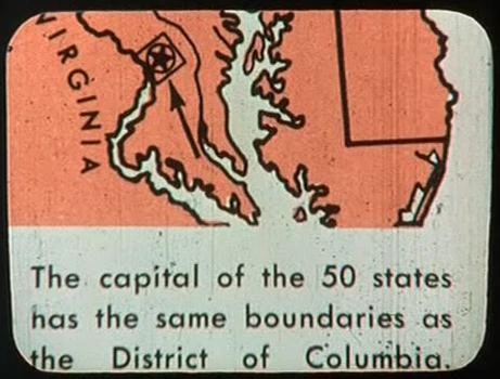
| + | {{bginfo|[[File:District of Columbia map.jpg|thumb|[[20th century]] map depicting part of Maryland]][[Retroactive continuity]]: Maps of North America showing parts of Maryland in relation to [[Washington, DC]] were downloaded from the {{USS|Enterprise|NCC-1701}} [[library computer]] by the [[Talosian]]s in [[2254]]. ({{TOS|The Cage}}) These maps were from educational texts available at the time of filming, {{y|1964}}.|The northern portion of Maryland was seen on a map of the United States (''Die Vereinigten Staaten von Amerika'').|The contours of this state were seen on a map of the United States in {{e|Little Green Men}}.}} |
||
{{US states}} |
{{US states}} |
||
| + | * [http://www.maryland.gov/ State of Maryland] - official web site |
||
| + | |||
| − | [[ |
+ | [[de:Maryland]] |
| + | [[fr:Maryland]] |
||
| + | [[it:Maryland]] |
||
| + | [[nl:Maryland]] |
||
| + | [[Category:Earth subnational entities]] |
||
Revision as of 17:40, 5 February 2015
AT: "xx" Maryland was a region located on the Atlantic coast of the North American continent of Earth. This was a state in the United States of America. The border states were Delaware, Pennsylvania, Virginia, West Virginia, and Washington, DC. One of its cities was Annapolis. (DS9: "Little Green Men"; ENT: "Storm Front", "Storm Front, Part II")
In an alternate timeline in which Nazi Germany had invaded the United States, as of 1944 Maryland was controlled by German forces. (ENT: "Storm Front", "Storm Front, Part II")
See also
20th century map depicting part of Maryland
The northern portion of Maryland was seen on a map of the United States (Die Vereinigten Staaten von Amerika).
The contours of this state were seen on a map of the United States in "Little Green Men".
| States and districts of the United States of America |
|---|
 |
External links
- Maryland at Memory Beta, the wiki for licensed Star Trek works
- Maryland at Wikipedia
- State of Maryland - official web site