Lakenheath72 (talk | contribs) No edit summary |
Lakenheath72 (talk | contribs) No edit summary |
||
| (One intermediate revision by the same user not shown) | |||
| Line 3: | Line 3: | ||
[[File:Tanks, Timestream.jpg|thumb|Tiananmen Square in [[1989]]]] |
[[File:Tanks, Timestream.jpg|thumb|Tiananmen Square in [[1989]]]] |
||
[[File:Richard M. Nixon.jpg|thumb|Nixon sets foot on Chinese soil in [[1972]]]] |
[[File:Richard M. Nixon.jpg|thumb|Nixon sets foot on Chinese soil in [[1972]]]] |
||
| − | '''China''' was a [[country]] in the eastern [[Asia]]n [[continent]] on [[Earth]]. The capital was [[Beijing |
+ | '''China''' was a [[country]] in the eastern [[Asia]]n [[continent]] on [[Earth]]. The capital was [[Beijing]]. This was the fourth largest country; only [[Russia]], [[Canada]], and the [[United States]] were larger. |
The [[Great Wall of China]] was constructed in the [[1st millennium BC|3rd century BC]] and fully connected by the first [[Qin]] [[emperor]] in order to prevent an invasion by [[nomad]]s to the north. ({{VOY|11:59}}) |
The [[Great Wall of China]] was constructed in the [[1st millennium BC|3rd century BC]] and fully connected by the first [[Qin]] [[emperor]] in order to prevent an invasion by [[nomad]]s to the north. ({{VOY|11:59}}) |
||
| Line 41: | Line 41: | ||
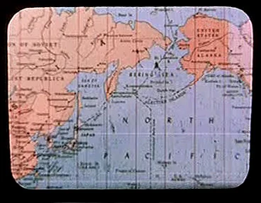
[[File:Earth map, 20th century, North Pacific.jpg|thumb|20th century era map of the North Pacific region. The east coast of China can be seen on this map.]] |
[[File:Earth map, 20th century, North Pacific.jpg|thumb|20th century era map of the North Pacific region. The east coast of China can be seen on this map.]] |
||
| − | [[Retroactive continuity]]: A [[20th century]]-era map of the North [[Pacific Ocean]] region, depicting the east coast of [[Asia]] and [[Alaska]] on the west coast of [[North America]], was stored in the {{USS|Enterprise|NCC-1701}}'s [[USS Enterprise (NCC-1701) library computer|library computer]] in [[2254]] |
+ | [[Retroactive continuity]]: A [[20th century]]-era map of the North [[Pacific Ocean]] region, depicting the east coast of [[Asia]] and [[Alaska]] on the west coast of [[North America]], was stored in the {{USS|Enterprise|NCC-1701}}'s [[USS Enterprise (NCC-1701) library computer|library computer]] in [[2254]]. This map was among the materials viewed by the [[Talosian]]s when they scanned the ''Enterprise'' computer. ({{TOS-R|The Cage}}) |
Early drafts of {{film|8}} were to have said that China was a leading member of the [[Eastern Coalition]] in the [[World War III|Third World War]], but it was decided that politics didn't really matter to the story, so the lines were cut. |
Early drafts of {{film|8}} were to have said that China was a leading member of the [[Eastern Coalition]] in the [[World War III|Third World War]], but it was decided that politics didn't really matter to the story, so the lines were cut. |
||
Revision as of 03:56, 7 February 2015
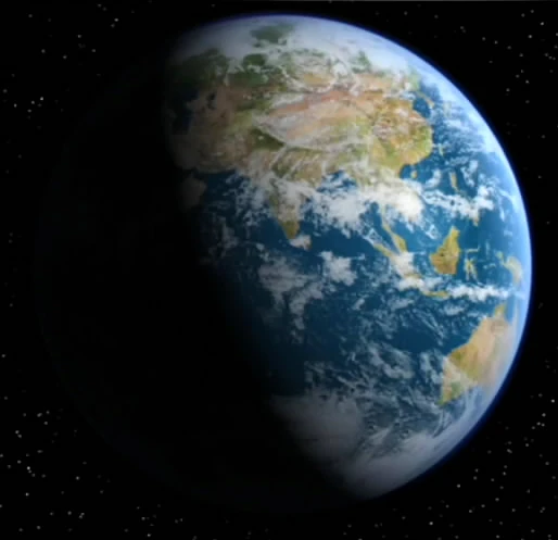
The eastern hemisphere of planet Earth, including China, India and Australia in 2154
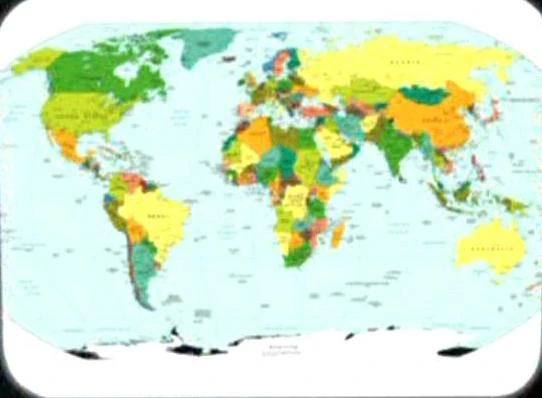
21st century era political map of Earth
Tiananmen Square in 1989
Nixon sets foot on Chinese soil in 1972
China was a country in the eastern Asian continent on Earth. The capital was Beijing. This was the fourth largest country; only Russia, Canada, and the United States were larger.
The Great Wall of China was constructed in the 3rd century BC and fully connected by the first Qin emperor in order to prevent an invasion by nomads to the north. (VOY: "11:59")
In 1932, seven women fell victim to the Redjac entity in Shanghai, the major port in China. (TOS: "Wolf in the Fold")
While visiting 1986 Earth, James T. Kirk described to Gillian Taylor why he was so interested in George and Gracie. When Kirk asked Taylor if she wanted the details, she told him, "I wouldn't miss this for all the tea in China." (Star Trek IV: The Voyage Home)
During San Francisco's Bell Riots, in 2024, Biddle Coleridge commented on the television coverage of the hostage situation, stating that "great, we're on every channel. I bet they're watching this in China." (DS9: "Past Tense, Part II")
In 2268, the situation on Neural reminded Captain Kirk of Earth's 20th century Brush Wars, and the Kohms of Omega IV reminded him of Asian communists. (TOS: "A Private Little War", "The Omega Glory")
A 21st century-era political map of Earth was stored in the USS Enterprise's library computer in 2254. The location of China was labeled on this map. This map was among the materials viewed by the Talosians when they scanned the Enterprise computer. (TOS-R: "The Cage")
In 2293, Spock stated that the Vulcans have a proverb: "only Nixon could go to China." (Star Trek VI: The Undiscovered Country)
In 2364, Captain Picard presented planetary ruler Lutan with a Sung Dynasty horse statue from 13th century China, on the occasion of the USS Enterprise-D's visit to Ligon II. (TNG: "Code of Honor")
In 2365, Picard, commenting on the hitherto indeterminate location of Iconia, reminded Wesley Crusher that China, too, had been thought a myth until Marco Polo reported his own journey there. (TNG: "Contagion")
Locations
Related link
Appendices
Background information
The map used in the remastered "The Cage" was a Central Intelligence Agency map published in September 2008. The ice shelfs of Antarctica were masked with black ink. Beijing was labeled on the map; its location was represented by a black star. [1]
20th century era map of the North Pacific region. The east coast of China can be seen on this map.
Retroactive continuity: A 20th century-era map of the North Pacific Ocean region, depicting the east coast of Asia and Alaska on the west coast of North America, was stored in the USS Enterprise's library computer in 2254. This map was among the materials viewed by the Talosians when they scanned the Enterprise computer. (TOS-R: "The Cage")
Early drafts of Star Trek: First Contact were to have said that China was a leading member of the Eastern Coalition in the Third World War, but it was decided that politics didn't really matter to the story, so the lines were cut.
Northern China was also mentioned as the starting point of an Orbital skydiving jump Kirk hoped to make in a deleted scene from Star Trek Generations.