HighwindBot (talk | contribs) m (thumb default alignment) |
Renegade54 (talk | contribs) m (- template) Tag: sourceedit |
||
| (21 intermediate revisions by 13 users not shown) | |||
| Line 1: | Line 1: | ||
| + | {{at|xx}} |
||
| − | [[Image:Cage-screen-17-North-Pacific.jpg|thumb|A map of Earth's [[Pacific Ocean]] showing the Bering Sea.]] |
||
| + | The '''Bering Sea''' was a sea on [[planet]] [[Earth]], which bordered the [[North America]]n region of [[Alaska]] and [[Union of Soviet Socialist Republics]] ([[Russia]]). The [[Arctic Circle]] passed through this sea. There were a small number of large islands in this sea. ({{film|4}}; {{film|11}}; ''[[Star Trek: Enterprise]] opening credits'') |
||
| − | The '''Bering Sea''' is a body of [[water]] on [[Earth]], lying between [[Alaska]] and [[Russia]]. |
||
| + | In the [[17th century]], the Bering Sea region had not yet been explored by [[European]] explorers. The region was within an area known as the "''America Septentrionalis''". (''[[Star Trek: Enterprise]]'', ''opening credits'') |
||
| − | In [[1986]], the [[humpback whale|humpback whales]] [[George]] and [[Gracie]] were released back into the wild in the Bering Sea. They nearly fell victim to pouchers before the men were scared off by the [[cloak|decloaking]] of a captured [[Klingon]] [[Klingon Bird-of-Prey|bird of prey]], dubbed [[HMS Bounty|HMS ''Bounty'']] by the [[officer|officers]] of the late [[starship]] [[USS Enterprise (NCC-1701)|USS ''Enterprise'']]. (''[[Star Trek IV: The Voyage Home]]'') |
||
| + | In [[1986]], the [[humpback whale]]s [[George and Gracie]] were released back into the wild in the Bering Sea. The whales were rescued from [[whale hunter]]s by the timely intervention of the {{HMS|Bounty}}. ({{film|4}}) |
||
| ⚫ | |||
| + | |||
| + | ''In the [[alternate reality]] of [[2258]], as the ''[[Narada]]'' approached [[Earth]], this sea could be seen on the ship's [[viewscreen]].'' ({{film|11}}) |
||
| + | |||
| + | == Background information == |
||
| + | Information on European exploration was from the 17th century map "Harmonia macrocosmica seu atlas universalis et novus, totius universi creati cosmographiam generalem, et novam exhibens", which was created by {{w|Andreas Cellarius}}. A scan of the original can be found [http://commons.wikimedia.org/wiki/File:Cellarius_Harmonia_Macrocosmica_-_Situs_Terrae_Circulis_coelestibus_Circundatae.jpg here] |
||
| + | |||
| + | This sea was labeled on a 21st century-era political map of Earth seen in the remastered {{e|The Cage}}. This was a Central Intelligence Agency map published either in April 2007[http://www.lib.utexas.edu/maps/world_maps/world_pol_2007.pdf] or September 2008.[http://www.lib.utexas.edu/maps/world_maps/world_pol_2008.pdf] The difference, which was not noticeable at the resolution of the image from the episode, was the addition of Kosovo, which gained its independence between the releases. The label "Bering Sea" was not legible to the viewer. |
||
| + | |||
| + | [[Retroactive continuity]]: A [[20th century]]-era map of the North Pacific Ocean was stored in the {{USS|Enterprise|NCC-1701}} [[library computer]] in [[2254]]. The Bering Sea was labeled on this map. This map was among the materials viewed by the [[Talosian]]s when they scanned the ''Enterprise'' computer. ({{TOS|The Cage}}) |
||
| + | |||
| + | <gallery> |
||
| + | File:Earth map, 20th century, North Pacific.jpg|20th century-era political map of the North Pacific Ocean of Earth |
||
| + | File:Earth political map.jpg|21st century-era political map of Earth |
||
| + | </gallery> |
||
| + | |||
| + | ==External links== |
||
| + | * {{NCwiki}} |
||
| + | * {{wikipedia}} |
||
[[de:Beringstraße]] |
[[de:Beringstraße]] |
||
| + | [[fr:Mer de Béring]] |
||
[[nl:Beringzee]] |
[[nl:Beringzee]] |
||
| ⚫ | |||
Revision as of 17:50, 17 April 2015
AT: "xx" The Bering Sea was a sea on planet Earth, which bordered the North American region of Alaska and Union of Soviet Socialist Republics (Russia). The Arctic Circle passed through this sea. There were a small number of large islands in this sea. (Star Trek IV: The Voyage Home; Star Trek; Star Trek: Enterprise opening credits)
In the 17th century, the Bering Sea region had not yet been explored by European explorers. The region was within an area known as the "America Septentrionalis". (Star Trek: Enterprise, opening credits)
In 1986, the humpback whales George and Gracie were released back into the wild in the Bering Sea. The whales were rescued from whale hunters by the timely intervention of the HMS Bounty. (Star Trek IV: The Voyage Home)
In the alternate reality of 2258, as the Narada approached Earth, this sea could be seen on the ship's viewscreen. (Star Trek)
Background information
Information on European exploration was from the 17th century map "Harmonia macrocosmica seu atlas universalis et novus, totius universi creati cosmographiam generalem, et novam exhibens", which was created by Andreas Cellarius. A scan of the original can be found here
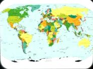
This sea was labeled on a 21st century-era political map of Earth seen in the remastered "The Cage". This was a Central Intelligence Agency map published either in April 2007[1] or September 2008.[2] The difference, which was not noticeable at the resolution of the image from the episode, was the addition of Kosovo, which gained its independence between the releases. The label "Bering Sea" was not legible to the viewer.
Retroactive continuity: A 20th century-era map of the North Pacific Ocean was stored in the USS Enterprise library computer in 2254. The Bering Sea was labeled on this map. This map was among the materials viewed by the Talosians when they scanned the Enterprise computer. (TOS: "The Cage")
External links
- Template:NCwiki
- Bering Sea at Wikipedia


