m (robot Adding: de:Antarktis) |
Lakenheath72 (talk | contribs) No edit summary Tag: sourceedit |
||
| (24 intermediate revisions by 17 users not shown) | |||
| Line 1: | Line 1: | ||
| − | [[ |
+ | [[File:Earth political map.jpg|thumb|21st century-era political map of Earth]] |
| + | [[File:Earth, The Blue Marble.jpg|thumb|Antarctica on planet Earth]] |
||
| − | '''Antarctica''' |
+ | '''Antarctica''' was a [[continent]] encompassing the southern-most area of the [[Earth]], including its south pole. |
| + | In the late [[17th century]], a cartographer created a map, from what was learned from [[European]] explorers and traders, of the lands that had coastlines on the [[Indian Ocean]] and [[Arabian Sea]]. Although Antarctica was unknown at this time, he included in his map a land called "''Terra Austr Incognita''" south of [[Australia|Nova Hollandia]]. This was centuries before humans discovered and explored this continent. (''[[Star Trek: Enterprise]]'', ''opening credits'') |
||
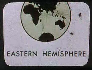
| − | A map of the Eastern hemisphere including Antarctica was in the [[USS Enterprise (NCC-1701)|USS ''Enterprise's'']] computers in [[2254]]. ([[TOS]]: "[[The Cage]]") |
||
| + | In the [[assignment patch]] for ''Apollo 7'' in the mid-[[20th century]], a peninsula of this continent was included in the design. ({{ENT|First Flight}}) |
||
| ⚫ | |||
| + | |||
| ⚫ | |||
| + | In the mid-[[20th century]], Antartica was seen on the the [[photograph]] "[[The Blue Marble]]". ({{TOS-R|The Cage}}) |
||
| + | |||
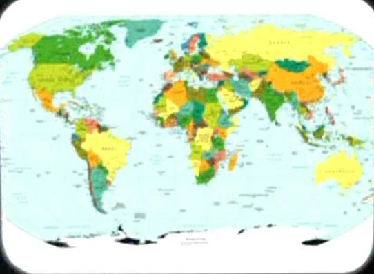
| + | A [[21st century]]-era political map of Earth was stored in the {{USS|Enterprise|NCC-1701}}'s [[USS Enterprise (NCC-1701) library computer|library computer]] in [[2254]]. Antarctica was seen on this map. This map was among the materials viewed by the [[Talosian]]s when they scanned the ''Enterprise'' computer. ({{TOS-R|The Cage}}) |
||
{{Earth continents}} |
{{Earth continents}} |
||
| + | |||
| ⚫ | |||
| + | {{bginfo|The 17th century map, known as "Harmonia macrocosmica seu atlas universalis et novus, totius universi creati cosmographiam generalem, et novam exhibens", was created by {{w|Andreas Cellarius}}. The {{w|Antarctic Circle}} was depicted as running through this land. A scan of the original can be found [http://commons.wikimedia.org/wiki/File:Cellarius_Harmonia_Macrocosmica_-_Situs_Terrae_Circulis_coelestibus_Circundatae.jpg here]|The map used in the remastered {{e|The Cage}} was a Central Intelligence Agency map published either in April 2007 ''[http://www.lib.utexas.edu/maps/world_maps/world_pol_2007.pdf]'' or September 2008 ''[http://www.lib.utexas.edu/maps/world_maps/world_pol_2008.pdf]''. The difference, which was not noticeable at the resolution of the image from the episode, was the addition of Kosovo, which gained its independence between the releases.|[[File:Eastern hemisphere graphic, The Cage.jpg|thumb|Antarctica on a map of Earth's eastern hemisphere]][[Retroactive continuity]]: A [[20th century]]-era map depicting a portion of the Antartica in the eastern hemisphere was stored in the {{USS|Enterprise|NCC-1701}} [[library computer]] in [[2254]]. This map were among the materials viewed by the [[Talosian]]s when they scanned the ''Enterprise'' computer. ({{TOS|The Cage}}}} |
||
| + | |||
| + | |||
| ⚫ | |||
| ⚫ | |||
[[de:Antarktis]] |
[[de:Antarktis]] |
||
| + | [[fr:Antarctique]] |
||
| + | [[it:Antartide]] |
||
| + | [[nl:Antarctica]] |
||
| ⚫ | |||
Revision as of 23:46, 1 March 2015
21st century-era political map of Earth
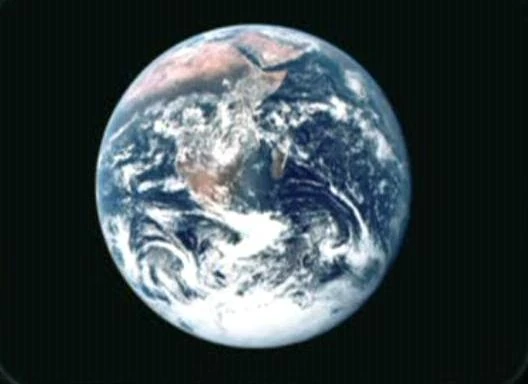
Antarctica on planet Earth
Antarctica was a continent encompassing the southern-most area of the Earth, including its south pole.
In the late 17th century, a cartographer created a map, from what was learned from European explorers and traders, of the lands that had coastlines on the Indian Ocean and Arabian Sea. Although Antarctica was unknown at this time, he included in his map a land called "Terra Austr Incognita" south of Nova Hollandia. This was centuries before humans discovered and explored this continent. (Star Trek: Enterprise, opening credits)
In the assignment patch for Apollo 7 in the mid-20th century, a peninsula of this continent was included in the design. (ENT: "First Flight")
In the mid-20th century, Antartica was seen on the the photograph "The Blue Marble". (TOS-R: "The Cage")
A 21st century-era political map of Earth was stored in the USS Enterprise's library computer in 2254. Antarctica was seen on this map. This map was among the materials viewed by the Talosians when they scanned the Enterprise computer. (TOS-R: "The Cage")
| Continents of Earth |
|---|
| Africa • Antarctica • Asia • Australia • Europe • North America • South America |
Antarctica on a map of Earth's eastern hemisphere