(+pic) |
No edit summary |
||
| (9 intermediate revisions by 3 users not shown) | |||
| Line 1: | Line 1: | ||
| + | {{at|xx}} |
||
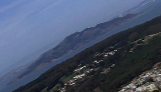
[[File:Angel Island 1986.jpg|thumb|Angel Island in [[1986]] ([[Presidio]] in front)]] |
[[File:Angel Island 1986.jpg|thumb|Angel Island in [[1986]] ([[Presidio]] in front)]] |
||
| − | '''Angel Island''' was a moderately sized island in the [[San Francisco |
+ | '''Angel Island''' was a moderately sized island in the [[San Francisco Metropolitan Area]]. The island was located in the northwest corner of [[San Francisco Bay]]. This island was located across the bay from [[San Francisco]]. |
| + | In [[1986]], the location of this island was depicted on a [[San Francisco Municipal Railway]] [[system map]]. As the [[HMS Bounty|HMS ''Bounty'']] was leaving San Francisco, this island was seen on the ship's [[viewscreen]]. ({{film|4}}) |
||
| − | {{bginfo|The location of Angel Island was identified on a [[MUNI]] map.}} |
||
| + | |||
| + | ''In the [[alternate reality]] of [[2259]], the {{USS|Vengeance}} flew over Angel Island during it's approach of San Francisco. In this timeline, much of the east side of the island was taken up by a large port facility, though the rest of the island remained forested. The island was also marked on a map of the San Francisco Bay. A point in Richardson Bay, a bay between [[Sausalito]] and [[Tiburon]], to a point on the southern coast of the island was connected by a line. This map was part of a collection of graphics and video media that were seen on a [[powerwall]] in the offices of [[Admiral]]s [[Christopher Pike (alternate reality)|Christopher Pike]] and [[Alexander Marcus (alternate reality)|Alexander Marcus]] at [[Starfleet Headquarters]].'' ({{film|12}}) |
||
| + | |||
| + | {{bginfo|Angel Island made an appearance in the director's edition of {{film|1}}.}} |
||
==External link== |
==External link== |
||
* {{wikipedia|Angel Island}} |
* {{wikipedia|Angel Island}} |
||
| + | |||
| + | [[fr:Angel Island]] |
||
[[Category:Earth geography]] |
[[Category:Earth geography]] |
||
Revision as of 02:20, 17 March 2014
AT: "xx"
Angel Island was a moderately sized island in the San Francisco Metropolitan Area. The island was located in the northwest corner of San Francisco Bay. This island was located across the bay from San Francisco.
In 1986, the location of this island was depicted on a San Francisco Municipal Railway system map. As the HMS Bounty was leaving San Francisco, this island was seen on the ship's viewscreen. (Star Trek IV: The Voyage Home)
In the alternate reality of 2259, the USS Vengeance flew over Angel Island during it's approach of San Francisco. In this timeline, much of the east side of the island was taken up by a large port facility, though the rest of the island remained forested. The island was also marked on a map of the San Francisco Bay. A point in Richardson Bay, a bay between Sausalito and Tiburon, to a point on the southern coast of the island was connected by a line. This map was part of a collection of graphics and video media that were seen on a powerwall in the offices of Admirals Christopher Pike and Alexander Marcus at Starfleet Headquarters. (Star Trek Into Darkness)